BIM in civil engineering: Uncharted territory with great potential


Building Information Modeling (BIM) is the word of the hour in the construction industry. There is hardly a specialist event in which the word does not appear. BIM has taken hold of the industry. The entire industry? No! BIM is only slowly finding its way into civil engineering. There are good reasons for this. However, initial pilot projects show that there is potential for using BIM in civil engineering.
While BIM has largely found its way into structural engineering, civil engineering and infrastructure construction are still cautious. "Compared to urban infrastructure, structural engineering is a simple object," says Regula Vedruccio-Stopper, Head of Geoinformatics at Basler & Hofmann. "It has a clear boundary and usually only belongs to one owner." The situation is much more complicated for an ordinary neighborhood street: Roads not only include the street itself with signalization, lighting and engineering structures, but also various service pipes. The number of owners is correspondingly large. Today, they maintain their data in very different ways. The variety ranges from paper archives to highly sophisticated GIS solutions. Working with BIM requires a common database that is gradually built up and maintained and can be linked to the owner's own systems. This requires close coordination between the parties involved.
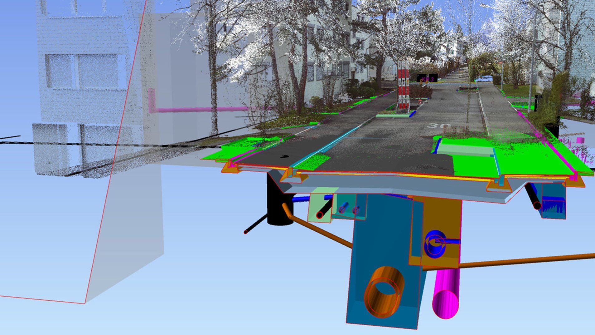
BIM model with connected database
In a BIM project, a database is built up alongside the three-dimensional model during the planning and construction process. In addition to the purely geometric data, a wealth of additional information can be stored for each object that is visualized in the model. What material is a service pipe made of? In what quality was the pavement of a Roads installed? Who laid the individual elements? And so on and so forth. Not all of the data is useful - and every piece of information recorded is time-consuming. "That's why it's crucial to determine right at the start which information the various owners really want to use in the future," says Regula Vedruccio-Stopper.
What added value does BIM offer?
The first question when starting a BIM project is therefore: How do we want to manage our Infrastructure(s) in the future? How can BIM create added value for us? And what information do we need for this? BIM already offers considerable advantages during project planning and construction: As all information is bundled in one model, spatial conflicts are already discovered and resolved in the planning phase - not just on the construction site. This reduces supplements. "However, the decisive factor for the use of BIM in infrastructure construction should be the added value for the client in the management phase and in the future use of the data," emphasizes Regula Vedruccio-Stopper.
Digital inventory of the Infrastructure
A fundamental advantage of BIM lies in the "as built" model - the exact digital image of the actual building. Although the two-dimensional paper plans commonly used today also promise this, they only offer selective cross-sections and are rarely truly complete and precise. As a result, there are always surprises under the road surface during the construction of projects. When building with BIM, all adjustments made on the construction site are transferred directly to the digital model. Depending on the owner's requirements, a great deal of additional data is added during construction.
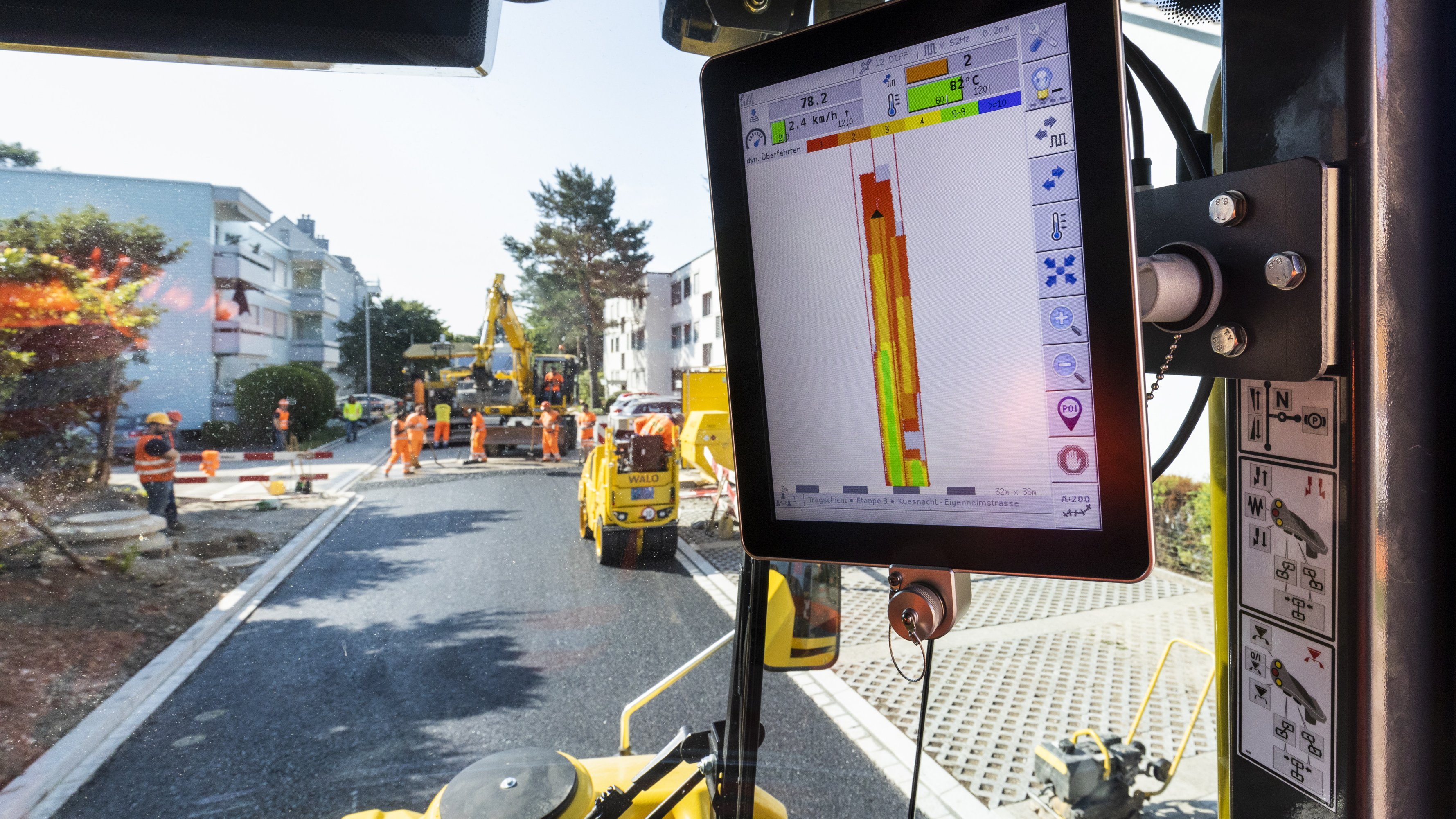
This is where digitalization meets the automation of construction machinery. For example, the machines can provide information on the compaction or paving temperature of the road surface. The paving quality is thus documented in a traceable manner. "The decisive factor is that all information is available in one place thanks to the combination of existing GIS information with the BIM database. This provides the owner with a successive digital inventory of the Infrastructure." In combination with a management tool for the value preservation of the Infrastructure, such as our "Stratus" software, it is possible to make much more precise statements about the financial resources required in the future. Regula Vedruccio therefore sees the greatest potential in maintenance and renovation planning. "The combination of BIM and GIS enables building owners to better manage life cycle costs and thus make targeted investment planning possible. Our vision is for owners to be able to see at a glance where and when what needs to be renewed in their network, which materials are already available and in what quantities, or which new materials need to be procured."
Step by step towards the future
This vision will not become reality overnight. This is because, unlike structural engineering, Infrastructure is a network. An individual renewal or concept design is a first building block. The added value of BIM will only be fully realized once a significant part of the network has been captured. This is a longer-term project that extends over decades. This makes it all the more important to start "collecting" the data early on. "Anyone starting with BIM in civil engineering today uses every project, no matter how small, to build the <digital twin> for their network. The ongoing investments, which have to be made anyway, flow into the system of the future instead of printed plans," recommends Regula Vedruccio-Stopper.


![[English] Buch Fachwissen Bau - Verkehrswegebau](/fileadmin/_processed_/3/c/csm_24-05-23_Buch_FachwissenBau_9d065b2879.jpg)